
I made the trip while getting over some bad bronchitis so the climbs were a little harder than I expected. Wasn't quite 100% but fresh air does a body good too. My pack is more of a 5 day pack than a 3 day pack but worked really well since it was a gift years back. Its a Lowe Alpine Frontier (large for long torso i.e. me). My buddy used a nice lightweight Gregory that worked great. Its a 2006 edition but can't remember what style it is. My pack probably better suited for like a trip in Europe or something to that effect. Gonna definitely use a lighter pack next time.

Edited pic courtesy Capt Jack...nice and cleaned up
http://i35.tinypic.com/2j67dsh.jpg" onclick="window.open(this.href);return false;
Checking out the views to the north from Guadalupe Peak.

Guadalupe Peak, highest point in Texas at 8,749 feet. The monument was placed there before it became a national park. It was done by American Airlines and Postal Service. Honors pilots and the Butterfield Stage route. Also a little ammo box contains a register to sign.

The view toward the northwest

Camped out about a mile from peak. Wind advisory that night. Had gusts all night over 50mph. Sounded like sleeping at an airport. Even with a windbreak. Everything held great though. Ate light as you pack in all water...each gallon adds 8lbs...yeesh. Woke up next morning sore but refreshed. After a rapid descent we embarked to the top end of the park.
Decided to go to the Wilderness Ridge, which includes a nice reef interpretive trail for geology buffs. A lot of good Permian period history here. The rangers mentioned folks rarely use the campground on the ridge..trail often used but not much past the ridge point. What a great decision it turned out to be. Passed a geology group but once on the ridge there was nary a soul.
Neat formation at lower elevation

The best part of this area are the primo views up high down into McKittrick Canyon....many folks miss out on this and just do the canyon day-trail.

The ridge is about 6800 feet.

Another nice bonus was a short hike and you are in New Mexico....Here is my buddy crossing into Lincoln National Forest where the rules are quite different...can have fires, hunt, four wheel trails, etc....

My trusty Mountain Hardwear Meridian 2 tent. Withstood all the high winds. For sleeping I used a very lightweight bag (Dicks sells a nice 30 degree bag for $25 that only weighs 2.2lbs), a silk bag liner, and a bivy--all that packed smaller and lighter than any heavy bags I owned that weighed from 3-5lbs. Of course carried my Thermarest prolite 3 too. And a small thermarest pillow too. For warmer temps I would have just taken bivy sack and silk liner but it got down to low 50s every night not counting wind chill

All food was light--tuna, jerky, clif bars, dried fruit, and some MREs for supper and calorie replacement.
Next morning view to canyon

Starting to see signs of color change...another couple weeks it and it will be prime color change season for the trees

Heading back down to McKittrick Canyon trail

Right off the bat on the Canyon Trail run into this fellar...very cool


Beautiful madrone trees. A rain forest relic that likes to live between 4500-6500ft.

The creek

The Wallace Pratt cabin. A very interesting structure and story. Pretty much took care of the area and donated much of the land that is now the park.

I would love to check this place out with snow on the ground

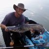
Ok so I promised fish...the creek has deeper holes upstream and spotted the trout...the view from above

Now with underwater mode. The clear water allowed for some great closeup shots of the trout


If you go past the grotto and make way up to the notch the views get better. My new desktop wallpaper.

Cool Madrone bark

More color change

"Manzanitas"

Besides gas cost....this trip cost me five bucks to get into the park for the whole trip!! Backcountry permits are free and last two weeks. (Its a designated wilderness area). Hiked 28 miles, mostly loaded, and was sore for it. Got there on a Thursday before noon and left early Saturday afternoon. Needless to say crammed a lot in under three full days. A true gem of a place to visit.


